
Gallery of Maps — Vatican Museums Visitor Guide
The 40 Maps, History & What to Look For
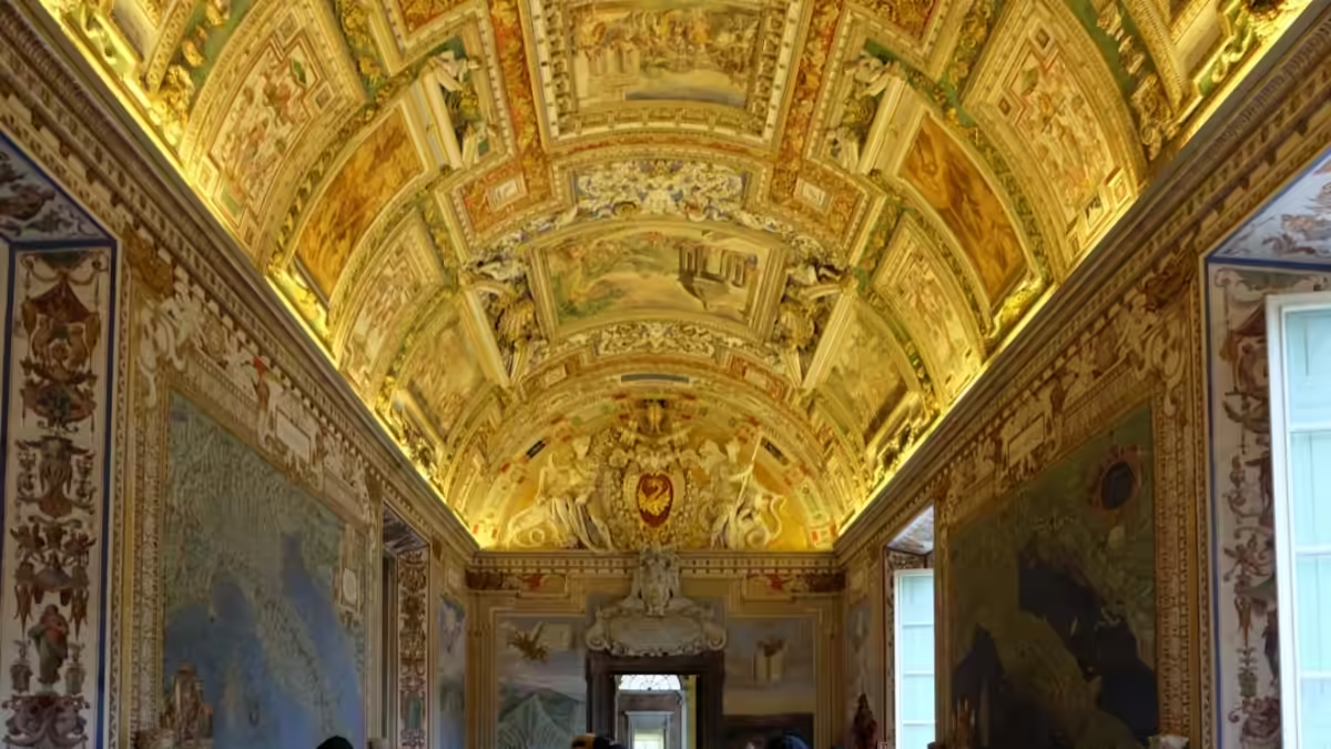
The Gallery of Maps (Galleria delle Carte Geografiche) is a 120-metre corridor on the upper floor of the Vatican Museums decorated with 40 large topographical fresco maps of Italy and its surrounding regions, commissioned by Pope Gregory XIII and painted by Ignazio Danti between 1580 and 1583. It sits between the Gallery of Tapestries and the Raphael Rooms on the standard visitor route. The maps cover the entire length of both walls. The ceiling above — equally elaborate, depicting scenes from the early Church — is one of the most overlooked painted surfaces in the Vatican. Photography is permitted. Allow 20–30 minutes.
The Gallery of Maps is one of the most photogenic and most immediately accessible spaces in the Vatican Museums. Unlike the Sistine Chapel (where you cannot photograph) or the Raphael Rooms (where the significance of the figures requires explanation), the Gallery of Maps rewards any visitor who simply walks its 120-metre length and looks carefully at the walls and ceiling. The maps are beautiful as images and historically extraordinary as documents — they show Italy in the 1580s, before the current political map existed, at a level of topographical detail that was revolutionary for the period.
Top Tickets
The 40 Maps — What They Show
The 40 fresco maps in the Gallery of Maps depict: the Italian peninsula divided into regions (west coast regions on the left wall as you enter from the Tapestries; east coast regions on the right wall); the major islands (Sicily, Sardinia, Corsica, Elba, Malta); the siege maps of papal territories; and maps of the port of Genoa and the environs of Venice. The maps are arranged so that the Italian peninsula faces itself across the corridor — regions facing their opposite coast. The large map of ancient Rome and a map showing the environs of the Vatican itself are among the most studied by visitors.
| Wall | Maps Depicted | Direction |
|---|---|---|
| Left wall (entering from Tapestries) | Western Italian regions: Liguria, Tuscany, Lazio, Campania, Calabria | North to south |
| Right wall | Eastern Italian regions: Veneto, Emilia-Romagna, Marche, Puglia, Basilicata | North to south |
| Both walls | Islands: Sicily, Sardinia, Corsica, Malta, Elba; port maps; siege maps | Various |
How to Read the Maps
The maps are oriented differently from modern convention — in several cases, south is at the top rather than north. This was not unusual for 16th-century cartography. The topographical detail is extraordinary: individual mountains, rivers, towns, and ports are depicted, with tiny ships at sea, forests on hillsides, and place names in a flowing 16th-century hand. The maps reward slow walking and close inspection.
The Map of Ancient Rome
Among the 40 maps, the large panel depicting the city of Rome occupies a prominent position. It shows Rome as it appeared in the ancient period — the major monuments of Imperial Rome, the Tiber’s course, the seven hills — rather than the contemporary 16th-century city. It is displayed alongside a companion map of contemporary 16th-century Rome, allowing visitors to compare the two cities at a glance.
The Sea Battles and Siege Maps
Several of the maps depict specific military and political events — the siege of Malta (1565), the Battle of Lepanto (1571), and scenes of papal territorial disputes. These are the most narratively complex of the 40 panels and repay careful examination of the inscriptions.
The Ceiling — The Most Overlooked Surface in the Vatican
The ceiling of the Gallery of Maps is painted with 32 large scenes depicting events from the history of the Catholic Church, separated by elaborate grotesque decoration in the style of the ancient Roman decoration discovered in Nero’s Domus Aurea. The ceiling was painted between 1580 and 1585 by a team of artists including Cesare Nebbia and Giovanni Guerra. It is as detailed and elaborate as the walls below — but almost universally missed by visitors absorbed in the maps. Spend at least 5 minutes looking up.
The ceiling scenes are arranged to correspond thematically with the maps below: events that occurred in a particular region of Italy are depicted in the ceiling above that region’s map. This cross-referencing between map and historical scene is the Gallery’s underlying intellectual programme — history and geography unified in a single space.
Ignazio Danti — The Map-Maker
The maps were designed by Ignazio Danti (1536–1586), a Dominican friar, mathematician, and the leading cartographer of his generation. Danti had already created the maps for the famous Guardaroba Nuova (wardrobe) in the Palazzo Vecchio in Florence for Cosimo I de’ Medici. Pope Gregory XIII brought him to Rome specifically for this project. Danti designed the maps based on existing surveys, written descriptions, and his own measurements — then supervised a team of painters who executed the frescoes. He completed the entire Gallery in three years.
Photography Tips
- Best shots: From either end of the corridor looking down the full 120m length — the vanishing-point perspective is the Gallery’s most distinctive visual quality
- Early morning: The 9am entry slot gives the clearest corridor shots before crowds fill the space. By 10:30am on busy days, photographing down the full length without other visitors in frame is difficult
- Look up: The ceiling is as photogenic as the walls — position yourself in the centre of the corridor and shoot upward
- Individual maps: Get close to individual panels to capture the topographical detail, ships at sea, and inscriptions
- No flash, no tripod: Flash is banned throughout the Vatican Museums; tripods are not permitted anywhere
Practical Information
- Location: Upper floor of the Vatican Museums, between the Gallery of Tapestries and the Raphael Rooms
- Length: 120 metres
- Number of maps: 40 fresco panels
- Commissioned by: Pope Gregory XIII
- Painted by: Ignazio Danti (design) and workshop, 1580–1583
- Ceiling painted: 1580–1585 by Cesare Nebbia, Giovanni Guerra, and others
- Photography: Permitted — no flash, no tripod
- Suggested time: 20–30 minutes
Frequently Asked Questions
Where is the Gallery of Maps in the Vatican Museums?
The Gallery of Maps is on the upper floor of the Vatican Museums, positioned between the Gallery of Tapestries and the Raphael Rooms on the standard visitor route. You cannot miss it — the corridor is 120 metres long and immediately recognisable.
How long does the Gallery of Maps take to visit?
Allow 20 to 30 minutes for a satisfying visit — long enough to walk the full length, examine individual maps closely, and spend time looking at the ceiling.
Can I take photos in the Gallery of Maps?
Yes — photography is fully permitted in the Gallery of Maps. Flash and tripods are not allowed.
Why is the Gallery of Maps important?
The Gallery of Maps is historically significant as one of the most ambitious cartographic projects of the 16th century — 40 detailed topographical maps of the entire Italian peninsula and surrounding regions, executed in fresco at monumental scale. It is also the most photogenic space in the Vatican Museums and the clearest demonstration of the Renaissance ideal of unifying art, science, and theology in a single programme.
What is on the ceiling of the Gallery of Maps?
The ceiling contains 32 large fresco scenes depicting events from the history of the Catholic Church, arranged to correspond with the maps below (events in a region depicted above that region’s map). It is as detailed as the walls but almost universally overlooked by visitors.
Related Guides
